
Bauxite topographic map
Interactive map
Click on the map to display elevation.
About this map
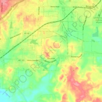
Name: Bauxite topographic map, elevation, terrain.
Location: Bauxite, Saline County, Arkansas, 72011, United States (34.54791 -92.53304 34.57755 -92.44124)
Average elevation: 120 m
Minimum elevation: 75 m
Maximum elevation: 173 m
Other topographic maps
Click on a map to view its topography, its elevation and its terrain.
Bauxite
United States > Arkansas > Saline County > Bauxite
Bauxite, Saline County, Arkansas, 72011, United States
Average elevation: 120 m