
Lac-Marguerite topographic map
Interactive map
Click on the map to display elevation.
About this map
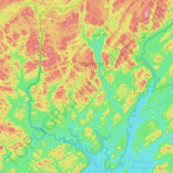
Name: Lac-Marguerite topographic map, elevation, terrain.
Location: Lac-Marguerite, Antoine-Labelle, Laurentides, Quebec, Canada (46.81416 -76.14926 47.21508 -75.74675)
Average elevation: 311 m
Minimum elevation: 213 m
Maximum elevation: 531 m
Other topographic maps
Click on a map to view its topography, its elevation and its terrain.
Lac Frime
Canada > Quebec > Antoine-Labelle > Lac-Marguerite
Lac Frime, Lac-Marguerite, Antoine-Labelle, Laurentides, Quebec, Canada
Average elevation: 245 m
Rivière-Rouge
Canada > Quebec > Antoine-Labelle
Rivière-Rouge, Antoine-Labelle, Laurentides, Quebec, Canada
Average elevation: 371 m
Lac Frime
Canada > Quebec > Antoine-Labelle > Lac-Marguerite
Lac Frime, Lac-Marguerite, Antoine-Labelle, Laurentides, Quebec, Canada
Average elevation: 246 m