
Brüggen topographic map
Interactive map
Click on the map to display elevation.
About this map
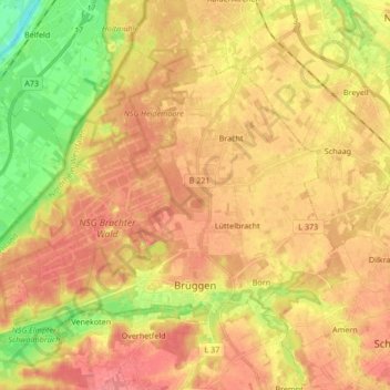
Name: Brüggen topographic map, elevation, terrain.
Location: Brüggen, Kreis Viersen, North Rhine-Westphalia, 41379, Germany (51.22732 6.07265 51.30745 6.24146)
Average elevation: 49 m
Minimum elevation: 9 m
Maximum elevation: 74 m
Other topographic maps
Click on a map to view its topography, its elevation and its terrain.
Nettetal
Germany > North Rhine-Westphalia > Kreis Viersen
Nettetal, Kreis Viersen, North Rhine-Westphalia, 41334, Germany
Average elevation: 51 m
Krinsend
Germany > North Rhine-Westphalia > Kreis Viersen > Schwalmtal > Waldniel
Krinsend, Waldniel, Schwalmtal, Kreis Viersen, North Rhine-Westphalia, 41366, Germany
Average elevation: 61 m
Kempen
Germany > North Rhine-Westphalia > Kreis Viersen
Kempen, Kreis Viersen, North Rhine-Westphalia, 47906, Germany
Average elevation: 35 m
Viersen
Germany > North Rhine-Westphalia > Kreis Viersen
Viersen, Kreis Viersen, North Rhine-Westphalia, Germany
Average elevation: 51 m