
Make a donation
Gear up for your next adventure:
As an Amazon Associate, this site earns from qualifying purchases at no extra cost to you.
Thimphu topographic map
Click on the map to display elevation.
Make a donation
Gear up for your next adventure:
As an Amazon Associate, this site earns from qualifying purchases at no extra cost to you.
Thimphu
The city extends in a north–south direction on the west bank of the valley formed by the Wang Chhu, which flows out into India as the Raidāk River. Thimphu is the fifth highest capital in the world by altitude and ranges in altitude from 2,248 metres (7,375 feet) to 2,648 metres (8,688 feet). Unusually for a capital city, Thimphu does not have its own airport, instead relying on the Paro Airport (connected by road some 52 kilometres (32 miles) away).
Make a donation
Gear up for your next adventure:
As an Amazon Associate, this site earns from qualifying purchases at no extra cost to you.
About this map
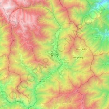
Name: Thimphu topographic map, elevation, terrain.
Location: Thimphu, Chang Gewog, Thimphu, Thimphu District, 11001, Bhutan (27.31135 89.47367 27.63135 89.79367)
Average elevation: 3,121 m
Minimum elevation: 1,485 m
Maximum elevation: 5,107 m
Make a donation
Gear up for your next adventure:
As an Amazon Associate, this site earns from qualifying purchases at no extra cost to you.