
Make a donation
Gear up for your next adventure:
As an Amazon Associate, this site earns from qualifying purchases at no extra cost to you.
Arc 1800 topographic map
Click on the map to display elevation.
Make a donation
Gear up for your next adventure:
As an Amazon Associate, this site earns from qualifying purchases at no extra cost to you.
About this map
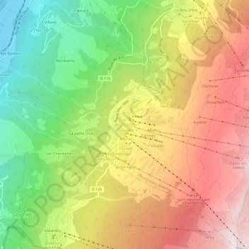
Name: Arc 1800 topographic map, elevation, terrain.
Average elevation: 1,633 m
Minimum elevation: 752 m
Maximum elevation: 2,542 m
Make a donation
Gear up for your next adventure:
As an Amazon Associate, this site earns from qualifying purchases at no extra cost to you.
Other topographic maps
Click on a map to view its topography, its elevation and its terrain.
73700
France > Auvergne-Rhône-Alpes > Savoy > Bourg-Saint-Maurice > Versoye-les-Granges
Average elevation: 1,999 m
73700
France > Auvergne-Rhône-Alpes > Savoy > Bourg-Saint-Maurice > Versoye-les-Granges
Average elevation: 1,999 m
Le Chantel
France > Auvergne-Rhône-Alpes > Savoy > Bourg-Saint-Maurice > Arc 1800
Average elevation: 1,770 m