
Bad Zwischenahn topographic map
Interactive map
Click on the map to display elevation.
About this map
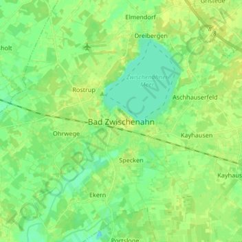
Name: Bad Zwischenahn topographic map, elevation, terrain.
Average elevation: 9 m
Minimum elevation: -3 m
Maximum elevation: 17 m
Other topographic maps
Click on a map to view its topography, its elevation and its terrain.
Edewecht
Germany > Lower Saxony > Landkreis Ammerland
Edewecht, Landkreis Ammerland, Lower Saxony, 26188, Germany
Average elevation: 8 m
Rastede
Germany > Lower Saxony > Landkreis Ammerland
Rastede, Landkreis Ammerland, Lower Saxony, 26180, Germany
Average elevation: 7 m