
French Guiana topographic map
Interactive map
Click on the map to display elevation.
French Guiana
French Guiana has an equatorial climate predominant. Located within six degrees of the Equator and rising only to modest elevations, French Guiana is hot and oppressively humid all year round. During most of the year, rainfall across the country is heavy due to the presence of the Intertropical Convergence Zone and its powerful thunderstorm cells. In most parts of French Guiana, rainfall is always heavy especially from December to July – typically over 330 millimetres or 13 inches can be expected each month during this period throughout the department. Between August and November, the eastern half experiences a warm dry season with rainfall below 100 millimetres or 3.94 inches and average high temperatures above 30 °C (86 °F) occurring in September and October, causing eastern French Guiana to be classified as a tropical monsoon climate (Köppen Am); Saint-Laurent-du-Maroni in the west has a tropical rainforest climate (Af).
About this map
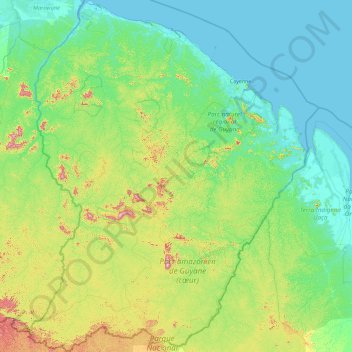
Name: French Guiana topographic map, elevation, terrain.
Location: French Guiana, France (2.11094 -54.60269 5.77695 -51.63461)
Average elevation: 103 m
Minimum elevation: -2 m
Maximum elevation: 791 m
Other topographic maps
Click on a map to view its topography, its elevation and its terrain.
Mont Blanc / Monte Bianco
France > Auvergne-Rhône-Alpes > Upper Savoy > Saint-Gervais-les-Bains
The climate is cold and temperate (Köppen climate classification Cfb), and is greatly influenced by altitude. Being the highest part of the Alps, Mont Blanc and surrounding mountains can create their own weather patterns. Temperatures drop as the mountains gain in height, and the summit of Mont Blanc is a…
Average elevation: 4,092 m
Molanès
France > Provence-Alpes-Côte d'Azur > Alpes-de-Haute-Provence > Uvernet-Fours
Average elevation: 1,566 m
Ailefroide
France > Provence-Alpes-Côte d'Azur > Hautes-Alpes > Vallouise-Pelvoux
Average elevation: 2,039 m
Saint-Valère
France > Bourgogne – Franche-Comté > Haute-Saône > Port-sur-Saône
Average elevation: 245 m
Le Caravon
France > Provence-Alpes-Côte d'Azur > Alpes-de-Haute-Provence > Oppedette
Average elevation: 553 m
Le Camp du Castellet
France > Provence-Alpes-Côte d'Azur > Var > Le Castellet
Average elevation: 371 m
Le Potin
France > Bourgogne – Franche-Comté > Nièvre > Châteauneuf-Val-de-Bargis
Average elevation: 300 m
Verdin
France > Bourgogne – Franche-Comté > Saône-et-Loire > Montagny-près-Louhans
Average elevation: 199 m
Le Chapet
France > Auvergne-Rhône-Alpes > Savoy > La Giettaz > La Giettaz-en-Aravis
Average elevation: 1,397 m
Aiguille du Midi
France > Auvergne-Rhône-Alpes > Upper Savoy > Chamonix-Mont-Blanc
The span of the second section is 2,867 m (1.781 mi) measured directly, but only 2,500 m (1.6 mi) measured horizontally. Thus it remains the second longest span width, measured directly. The cable car travels from Chamonix to the top of the Aiguille du Midi – an altitude gain of over 2,800 m (9,200 ft) –…
Average elevation: 3,098 m
Mont Joly
France > Auvergne-Rhône-Alpes > Upper Savoy > Saint-Gervais-les-Bains
Average elevation: 1,978 m
Château d'Estours
France > Bourgogne – Franche-Comté > Saône-et-Loire > Crêches-sur-Saône > Estours
Average elevation: 183 m
Jardins de l'Hôtel du Département
France > Bourgogne – Franche-Comté > Jura > Lons-le-Saunier
Average elevation: 299 m
Le Grand Village
France > Centre-Val de Loire > Indre-et-Loire > La Ville-aux-Dames
Average elevation: 51 m
Flaine
France > Auvergne-Rhône-Alpes > Upper Savoy
The site is divided into two areas which are joined by two free lifts. The upper area, Flaine Forêt, at an altitude of 1700 m, consists of a number of apartment buildings named after constellations, the Éric et Sylvie Boissonnas Auditorium, shops, offices and restaurants. The lower area, Flaine Forum, at an…
Average elevation: 1,850 m
Laniac
France > Auvergne-Rhône-Alpes > Haute-Loire > Siaugues-Sainte-Marie > Siaugues-Saint-Romain
Average elevation: 909 m
Beaune-le-Chaud
France > Auvergne-Rhône-Alpes > Puy-de-Dôme > Saint-Genès-Champanelle
Average elevation: 941 m
Les Rieux Vieux
France > Nouvelle-Aquitaine > Haute-Vienne > Saint-Pardoux-le-Lac
Average elevation: 380 m
Glacier de la Grande Casse
France > Auvergne-Rhône-Alpes > Savoy > Pralognan-la-Vanoise
Average elevation: 2,896 m
Le Clau du Bois
France > Nouvelle-Aquitaine > Dordogne > Saint-Romain-et-Saint-Clément
Average elevation: 221 m
Chavailles
France > Provence-Alpes-Côte d'Azur > Alpes-de-Haute-Provence > Prads-Haute-Bléone
Average elevation: 1,491 m
Monte Cinto
France > Corsica > Haute-Corse > Lozzi
The elevation of the mountain is 2,706 metres (8,878 ft) and so is its prominence, making it one of the most prominent peaks in Europe. It is the highest peak of the Monte Cinto massif, one of the four main massifs in Corsica.
Average elevation: 2,151 m