
Make a donation
Gear up for your next adventure:
As an Amazon Associate, this site earns from qualifying purchases at no extra cost to you.
Morning Sun topographic map
Click on the map to display elevation.
Make a donation
Gear up for your next adventure:
As an Amazon Associate, this site earns from qualifying purchases at no extra cost to you.
Morning Sun
Sol de Mañana is an area with geothermal manifestations in southern Bolivia, including fumaroles, hot springs and mud pools. It lies at about 4,900 metres (16,100 ft) elevation, south of Laguna Colorada and east of El Tatio geothermal field. The field is located within the Eduardo Avaroa Andean Fauna National Reserve and is an important tourism attraction on the road between Uyuni and Antofagasta. The field has been prospected as a possible geothermal power production site, with research beginning in the 1970s and after a pause recommencing in 2010. Development is ongoing as of 2023.
Make a donation
Gear up for your next adventure:
As an Amazon Associate, this site earns from qualifying purchases at no extra cost to you.
About this map
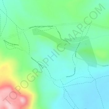
Name: Morning Sun topographic map, elevation, terrain.
Average elevation: 4,894 m
Minimum elevation: 4,815 m
Maximum elevation: 5,076 m
Make a donation
Gear up for your next adventure:
As an Amazon Associate, this site earns from qualifying purchases at no extra cost to you.
Other topographic maps
Click on a map to view its topography, its elevation and its terrain.
Laguna Salada
Bolivia > Potosí > Provincia Sur Lípez > Municipio San Pablo de Lipez
Average elevation: 4,390 m
Uturuncu
Bolivia > Potosí > Provincia Sur Lípez > Municipio San Pablo de Lipez
At an elevation of 6,008 metres (19,711 ft), Uturuncu is the highest mountain in southwestern Bolivia. It dominates the regional geomorphology, rising about 1,510–1,670 metres (4,950–5,480 ft) above the surrounding terrain and presenting a good view of the surrounding mountains from the summit. The volcano…
Average elevation: 5,594 m
Quetena Chico
Bolivia > Potosí > Provincia Sur Lípez > Municipio San Pablo de Lipez > Quetena Chico
Average elevation: 4,196 m