
Make a donation
Gear up for your next adventure:
As an Amazon Associate, this site earns from qualifying purchases at no extra cost to you.
Annur topographic map
Click on the map to display elevation.
Make a donation
Gear up for your next adventure:
As an Amazon Associate, this site earns from qualifying purchases at no extra cost to you.
Annur
Annur is located at 11°14′N 77°08′E / 11.23°N 77.13°E / 11.23; 77.13. It has an average elevation of 338 metres (1108 feet). Annur is well connected by roads including the National Highway 209 (New NH948) (Coimbatore to Bangalore highway) and the State Highway 80 SH80 Avanashi to Mettupalayam passes through Annur.
Make a donation
Gear up for your next adventure:
As an Amazon Associate, this site earns from qualifying purchases at no extra cost to you.
About this map
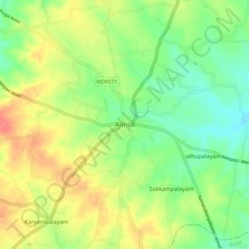
Name: Annur topographic map, elevation, terrain.
Location: Annur, Coimbatore North, Coimbatore, Tamil Nadu, 641653, India (11.19297 77.06352 11.27297 77.14352)
Average elevation: 381 m
Minimum elevation: 356 m
Maximum elevation: 412 m
Make a donation
Gear up for your next adventure:
As an Amazon Associate, this site earns from qualifying purchases at no extra cost to you.
Other topographic maps
Click on a map to view its topography, its elevation and its terrain.