
Make a donation
Gear up for your next adventure:
As an Amazon Associate, this site earns from qualifying purchases at no extra cost to you.
Alcamo topographic map
Click on the map to display elevation.
Make a donation
Gear up for your next adventure:
As an Amazon Associate, this site earns from qualifying purchases at no extra cost to you.
Alcamo
Alcamo is situated in the middle of the Gulf of Castellammare, at 258 metres above the sea level and at the foot of Mount Bonifato, a calcareous complex 825 metres high. At the altitude of 500 metres (near the "Funtanazza") there is the Nature Reserve of Monte Bonifato.
Make a donation
Gear up for your next adventure:
As an Amazon Associate, this site earns from qualifying purchases at no extra cost to you.
About this map
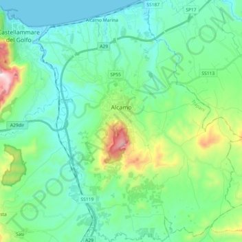
Name: Alcamo topographic map, elevation, terrain.
Location: Alcamo, Trapani, Sicily, 91011, Italy (37.89705 12.89640 38.03989 13.05403)
Average elevation: 193 m
Minimum elevation: 0 m
Maximum elevation: 900 m
Make a donation
Gear up for your next adventure:
As an Amazon Associate, this site earns from qualifying purchases at no extra cost to you.
Other topographic maps
Click on a map to view its topography, its elevation and its terrain.