
Make a donation
Gear up for your next adventure:
As an Amazon Associate, this site earns from qualifying purchases at no extra cost to you.
New Mills topographic map
Click on the map to display elevation.
Make a donation
Gear up for your next adventure:
As an Amazon Associate, this site earns from qualifying purchases at no extra cost to you.
New Mills
High Peak Borough Council have produced a Conservation Area Character Appraisal document, outlining the reasons that the Conservation Area has been designated as such. In justifying the reasons for designation, this document states of the town: "New Mills is a town of dramatic topography and origins that date back to the 14th century. Its topography and the supply of fast flowing waters led to its development as a thriving mill town and important centre for the textile industry. Its impressive landscape developed much of its developed form and the townscape that we still see today."
Make a donation
Gear up for your next adventure:
As an Amazon Associate, this site earns from qualifying purchases at no extra cost to you.
About this map
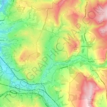
Name: New Mills topographic map, elevation, terrain.
Average elevation: 251 m
Minimum elevation: 90 m
Maximum elevation: 455 m
Derbyshire trails, hiking, mountain biking, running and outdoor activities
Make a donation
Gear up for your next adventure:
As an Amazon Associate, this site earns from qualifying purchases at no extra cost to you.