Geolocate

Tryon topographic map

Click on the map to display elevation.

Tryon

The elevation of the town is 1,067 feet (325 m) above sea level. The town's original boundary was established as a circle with a radius of three quarters of a mile. According to the United States Census Bureau, the town has a total area of 1.8 square miles (4.7 km2), all land.

Wikipedia (CC-BY-SA 3.0)

About this map

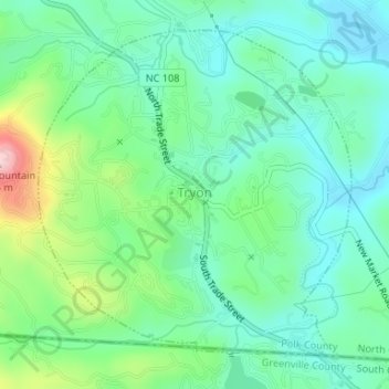
Name: Tryon topographic map, elevation, terrain.

Location: Tryon, Polk County, North Carolina, United States (35.19654 -82.25175 35.21942 -82.22512)

Average elevation: 333 m

Minimum elevation: 272 m

Maximum elevation: 498 m

Other topographic maps

Click on a map to view its topography, its elevation and its terrain.

Beulah

United States > North Carolina > Polk County

Average elevation: 287 m

Mill Spring

United States > North Carolina > Polk County

Average elevation: 318 m

Cox

United States > North Carolina > Polk County

Average elevation: 251 m

Peniel

United States > North Carolina > Polk County

Average elevation: 326 m

Mill Spring

United States > North Carolina > Polk County

Average elevation: 318 m

Howard Gap

United States > North Carolina > Polk County

Average elevation: 573 m

Gear up for your next adventure:

Lightweight Tents - Compact tents for backpacking and trekking
🪢Paracord - Multi-purpose cord for camping and survival
🧴Tick Removal Tools - Small, essential health tool for UK woodland and moorland
🦯Walking Poles - Supportive poles for long-distance walking
🎒Multi-day Trekking Packs - Large capacity backpacks for wild camping and long-distance trails

As an Amazon Associate, this site earns from qualifying purchases at no extra cost to you.