Geolocate

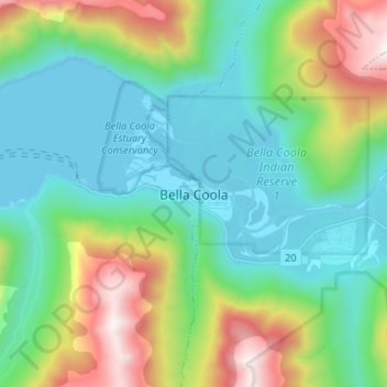
Bella Coola topographic map

Click on the map to display elevation.

Bella Coola

There is a 454 km mostly paved road connection by Highway 20 to Williams Lake. The 137 kilometre section from Bella Coola to Anahim Lake was built in 1953 by local residents, and features a 15 km ascent from the Valley floor to the Chilcotin plateau, gaining 1600 metres in elevation to the summit at Heckman Pass, via a number of steep grades & switchbacks. The construction of this road was described in the books "Bella Coola" and "A Road Runs West".

Wikipedia (CC-BY-SA 3.0)

About this map

Name: Bella Coola topographic map, elevation, terrain.

Location: Bella Coola, Area E (West Bella Coola/Clayton Falls/Tallheo), Central Coast Regional District, British Columbia, V0T 1C0, Canada (52.33230 -126.79568 52.41230 -126.71568)

Average elevation: 438 m

Minimum elevation: -1 m

Maximum elevation: 1,609 m

Gear up for your next adventure:

🐕Dog Hiking Gear - Equipment for hiking safely with dogs
🔋Lithium AA Batteries - Long-lasting power that performs well in cold mountain weather
👟Waterproof Leg Gaiters - Keep mud and water out of your boots in boggy terrain
🌂Windproof Trekking Umbrellas - Surprising but effective rain protection on low-wind trails
🔭Compact Hiking Binoculars - Lightweight optics for scouting terrain and spotting wildlife

As an Amazon Associate, this site earns from qualifying purchases at no extra cost to you.