
Casola in Lunigiana topographic map
Interactive map
Click on the map to display elevation.
About this map
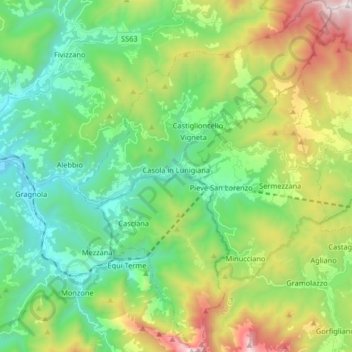
Name: Casola in Lunigiana topographic map, elevation, terrain.
Average elevation: 642 m
Minimum elevation: 138 m
Maximum elevation: 1,773 m
Other topographic maps
Click on a map to view its topography, its elevation and its terrain.
Regnano-Castello
Italy > Tuscany > Casola in Lunigiana
Regnano-Castello, Casola in Lunigiana, Unione di comuni Montana Lunigiana, Massa-Carrara, Tuscany, 54014, Italy
Average elevation: 817 m