
Cortez topographic map
Interactive map
Click on the map to display elevation.
About this map
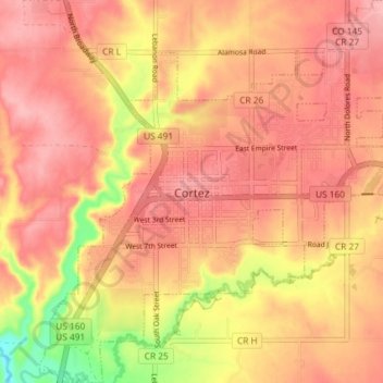
Name: Cortez topographic map, elevation, terrain.
Location: Cortez, Montezuma County, Colorado, 81321, United States (37.32059 -108.61311 37.37853 -108.54509)
Average elevation: 1,865 m
Minimum elevation: 1,784 m
Maximum elevation: 1,901 m
Cortez has a dry-summer continental climate (Köppen Dsb), though it borders on a semi-arid climate (BSk) due to low precipitation. The city has hot summer days and cold winter nights, the latter a result of its elevation.
Other topographic maps
Click on a map to view its topography, its elevation and its terrain.
Park Point
United States > Colorado > Montezuma County
Park Point, Montezuma County, Colorado, United States
Average elevation: 2,395 m