Geolocate

Clark topographic map

Click on the map to display elevation.

About this map
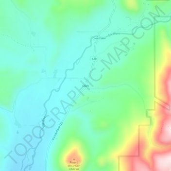
Name: Clark topographic map, elevation, terrain.

Location: Clark, Routt County, Colorado, 80428, United States (40.68608 -106.93922 40.72608 -106.89922)

Average elevation: 2,277 m

Minimum elevation: 2,173 m

Maximum elevation: 2,572 m

Other topographic maps

Click on a map to view its topography, its elevation and its terrain.

Steamboat Springs

United States > Colorado > Routt County

Average elevation: 2,228 m

Oak Creek

United States > Colorado > Routt County

Average elevation: 2,325 m

Steamboat Springs

United States > Colorado > Routt County

Average elevation: 2,228 m

Yampa

United States > Colorado > Routt County

Yampa has a humid continental climate (Köppen climate classification Dfb), with warm summers and long, cold, snowy winters. Due to altitude and dryness, the diurnal temperature variation is large throughout the year, especially in summer, and the growing season is short, typically averaging just 80 days.

Average elevation: 2,422 m

Steamboat Lake

United States > Colorado > Routt County

Average elevation: 2,464 m

Steamboat Springs

United States > Colorado > Routt County

Average elevation: 2,228 m

Oak Creek

United States > Colorado > Routt County > Oak Creek

Average elevation: 2,325 m

Oak Creek

United States > Colorado > Routt County

Average elevation: 2,325 m

Gear up for your next adventure:

🧗Locking Carabiners - Secure gear to your pack or for light technical use
🧭Professional Hiking Compasses - High-precision liquid-filled compasses for map reading and orientation
🚲Cycling GPS Computers - Track elevation and topographic routes on two wheels
🖼️Topographic Map Art - Decorative 3D-effect posters of famous UK peaks and regions
🧢Waterproof Hiking Hats - Keep the rain off your face while studying topographic maps

As an Amazon Associate, this site earns from qualifying purchases at no extra cost to you.