
Make a donation
Gear up for your next adventure:
As an Amazon Associate, this site earns from qualifying purchases at no extra cost to you.
Nyala topographic map
Click on the map to display elevation.
Make a donation
Gear up for your next adventure:
As an Amazon Associate, this site earns from qualifying purchases at no extra cost to you.
Nyala
When the United Kingdom conquered present-day Sudan, the British commander-in-chief met Sultan Adam Suleiman in 1932, seeking his advice for his knowledge of the best places in terms of availability of water sources and land topography in order to establish the British Administration Headquarters in Darfur. Sultan Adam Suleiman had chosen Nyala for that purpose.
Make a donation
Gear up for your next adventure:
As an Amazon Associate, this site earns from qualifying purchases at no extra cost to you.
About this map
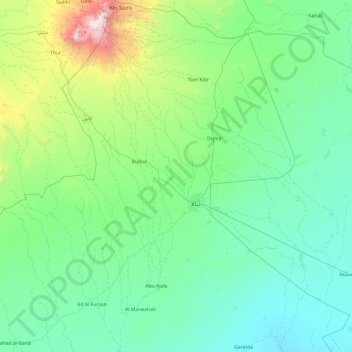
Name: Nyala topographic map, elevation, terrain.
Location: Nyala, Sudan (11.25368 24.32513 13.13302 25.72290)
Average elevation: 764 m
Minimum elevation: 465 m
Maximum elevation: 2,983 m
Make a donation
Gear up for your next adventure:
As an Amazon Associate, this site earns from qualifying purchases at no extra cost to you.
Other topographic maps
Click on a map to view its topography, its elevation and its terrain.
Make a donation
Gear up for your next adventure:
As an Amazon Associate, this site earns from qualifying purchases at no extra cost to you.