
Make a donation
Gear up for your next adventure:
As an Amazon Associate, this site earns from qualifying purchases at no extra cost to you.
Satyamangalam topographic map
Click on the map to display elevation.
Make a donation
Gear up for your next adventure:
As an Amazon Associate, this site earns from qualifying purchases at no extra cost to you.
Satyamangalam
Sathyamangalam is situated in the region between the Eastern and Western Ghats, which are separated by the Moyar River valley in Nilgiris towards the north. The general topography is not flat and covered by sloping lands. Bhavani river flows at the center of the town from west to east. Agricultural wet lands are predominant on both sides of the river and dry lands are predominant on the northern side of the town. The soil mainly consists of black loam, red loam and red sand.
Make a donation
Gear up for your next adventure:
As an Amazon Associate, this site earns from qualifying purchases at no extra cost to you.
About this map
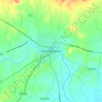
Name: Satyamangalam topographic map, elevation, terrain.
Average elevation: 248 m
Minimum elevation: 224 m
Maximum elevation: 310 m
Make a donation
Gear up for your next adventure:
As an Amazon Associate, this site earns from qualifying purchases at no extra cost to you.
Other topographic maps
Click on a map to view its topography, its elevation and its terrain.