
Untergriesbach topographic map
Interactive map
Click on the map to display elevation.
About this map
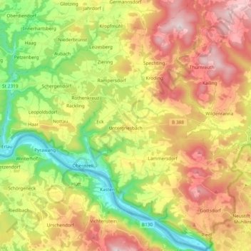
Name: Untergriesbach topographic map, elevation, terrain.
Location: Untergriesbach, Landkreis Passau, Bavaria, 94107, Germany (48.51302 13.58171 48.63615 13.75572)
Average elevation: 538 m
Minimum elevation: 278 m
Maximum elevation: 839 m
Other topographic maps
Click on a map to view its topography, its elevation and its terrain.
Muth
Germany > Bavaria > Landkreis Passau > Loizersdorf
Muth, Loizersdorf, Tittling, Tittling (VGem), Landkreis Passau, Bavaria, 94104, Germany
Average elevation: 474 m
Hutthurm
Germany > Bavaria > Landkreis Passau
Hutthurm, Landkreis Passau, Bavaria, 94116, Germany
Average elevation: 432 m
Dobl
Germany > Bavaria > Landkreis Passau > Vilshofen an der Donau > Dobl
Dobl, Vilshofen an der Donau, Landkreis Passau, Bavaria, 94474, Germany
Average elevation: 398 m