
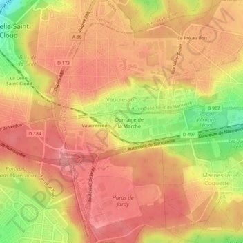
Vaucresson topographic map
Interactive map
Click on the map to display elevation.
About this map
Name: Vaucresson topographic map, elevation, terrain.
Average elevation: 157 m
Minimum elevation: 96 m
Maximum elevation: 185 m
Other topographic maps
Click on a map to view its topography, its elevation and its terrain.
Le Plessis-Robinson
France > Ile-de-France > Hauts-de-Seine
Le Plessis-Robinson, Antony, Hauts-de-Seine, Ile-de-France, Metropolitan France, 92350, France
Average elevation: 146 m
Résidence Parc de Béarn
France > Ile-de-France > Hauts-de-Seine > Saint-Cloud
Résidence Parc de Béarn, Saint-Cloud, Arrondissement of Nanterre, Hauts-de-Seine, Ile-de-France, Metropolitan France, 92210, France
Average elevation: 71 m
Jardin de la Mairie
France > Ile-de-France > Hauts-de-Seine > Boulogne-Billancourt
Jardin de la Mairie, Centre Ville, Boulogne-Billancourt, Hauts-de-Seine, Ile-de-France, Metropolitan France, 92100, France
Average elevation: 52 m
Quartier Boieldieu
France > Ile-de-France > Hauts-de-Seine > Puteaux
Quartier Boieldieu, Puteaux, Arrondissement of Nanterre, Hauts-de-Seine, Ile-de-France, Metropolitan France, 92800, France
Average elevation: 52 m
Antony
France > Ile-de-France > Hauts-de-Seine
Antony, Hauts-de-Seine, Ile-de-France, Metropolitan France, 92160, France
Average elevation: 76 m
Residence Foch
France > Ile-de-France > Hauts-de-Seine > Garches
Residence Foch, Garches, Arrondissement of Nanterre, Hauts-de-Seine, Ile-de-France, Metropolitan France, 92380, France
Average elevation: 129 m
Bois-Colombes
France > Ile-de-France > Hauts-de-Seine
Bois-Colombes, Arrondissement of Nanterre, Hauts-de-Seine, Ile-de-France, Metropolitan France, 92270, France
Average elevation: 39 m
Quartier Mont-Valérien
France > Ile-de-France > Hauts-de-Seine > Suresnes
Quartier Mont-Valérien, Suresnes, Arrondissement of Nanterre, Hauts-de-Seine, Ile-de-France, Metropolitan France, 92150, France
Average elevation: 76 m
Levallois-Perret
France > Ile-de-France > Hauts-de-Seine
Levallois-Perret, Arrondissement of Nanterre, Hauts-de-Seine, Ile-de-France, Metropolitan France, 92300, France
Average elevation: 40 m
Montrouge
France > Ile-de-France > Hauts-de-Seine
Montrouge, Antony, Hauts-de-Seine, Ile-de-France, Metropolitan France, 92120, France
Average elevation: 76 m
Puteaux
France > Ile-de-France > Hauts-de-Seine
Puteaux, Arrondissement of Nanterre, Hauts-de-Seine, Ile-de-France, Metropolitan France, 92800, France
Average elevation: 52 m
Val Saint-Olaf
France > Ile-de-France > Hauts-de-Seine > Chaville > Val Saint-Olaf
Val Saint-Olaf, Chaville, Boulogne-Billancourt, Hauts-de-Seine, Ile-de-France, Metropolitan France, 92370, France
Average elevation: 128 m
Parc de Billancourt
France > Ile-de-France > Hauts-de-Seine > Boulogne-Billancourt
Parc de Billancourt, Rives de Seine, Boulogne-Billancourt, Hauts-de-Seine, Ile-de-France, Metropolitan France, 92100, France
Average elevation: 58 m
Clamart
France > Ile-de-France > Hauts-de-Seine > Clamart > Clamart
Clamart, Antony, Hauts-de-Seine, Ile-de-France, Metropolitan France, 92140, France
Average elevation: 104 m
Villeneuve-la-Garenne
France > Ile-de-France > Hauts-de-Seine > Villeneuve-la-Garenne
Villeneuve-la-Garenne, Arrondissement of Nanterre, Hauts-de-Seine, Ile-de-France, Metropolitan France, 92390, France
Average elevation: 33 m
Bagneux
France > Ile-de-France > Hauts-de-Seine > Bagneux
Bagneux, Antony, Hauts-de-Seine, Ile-de-France, Metropolitan France, 92220, France
Average elevation: 91 m
Bois de Boulogne
France > Ile-de-France > Hauts-de-Seine > Neuilly-sur-Seine
Bois de Boulogne, Neuilly-sur-Seine, Arrondissement of Nanterre, Hauts-de-Seine, Ile-de-France, Metropolitan France, 92200, France
Average elevation: 43 m
Courbevoie
France > Ile-de-France > Hauts-de-Seine
Courbevoie, Arrondissement of Nanterre, Hauts-de-Seine, Ile-de-France, Metropolitan France, 92400, France
Average elevation: 44 m
Meudon
France > Ile-de-France > Hauts-de-Seine
Meudon, Boulogne-Billancourt, Hauts-de-Seine, Ile-de-France, Metropolitan France, France
Average elevation: 132 m
Vanves
France > Ile-de-France > Hauts-de-Seine
Vanves, Boulogne-Billancourt, Hauts-de-Seine, Ile-de-France, Metropolitan France, 92170, France
Average elevation: 67 m
Nanterre
France > Ile-de-France > Hauts-de-Seine > Nanterre
Nanterre, Arrondissement of Nanterre, Hauts-de-Seine, Ile-de-France, Metropolitan France, 92000, France
Average elevation: 45 m
Boulogne-Billancourt
France > Ile-de-France > Hauts-de-Seine
Boulogne-Billancourt, Hauts-de-Seine, Ile-de-France, Metropolitan France, 92100, France
Average elevation: 43 m
Neuilly-sur-Seine
France > Ile-de-France > Hauts-de-Seine
Neuilly-sur-Seine, Arrondissement of Nanterre, Hauts-de-Seine, Ile-de-France, Metropolitan France, 92200, France
Average elevation: 41 m
Malakoff
France > Ile-de-France > Hauts-de-Seine
Malakoff, Antony, Hauts-de-Seine, Ile-de-France, Metropolitan France, 92240, France
Average elevation: 76 m
Issy-les-Moulineaux
France > Ile-de-France > Hauts-de-Seine
Issy-les-Moulineaux, Boulogne-Billancourt, Hauts-de-Seine, Ile-de-France, Metropolitan France, 92130, France
Average elevation: 60 m