
Thank you for supporting this site ❤️
Make a donation
Make a donation
Gear up for your next adventure:
As an Amazon Associate, this site earns from qualifying purchases at no extra cost to you.
Oberviechtach topographic map
Click on the map to display elevation.
Thank you for supporting this site ❤️
Make a donation
Make a donation
Gear up for your next adventure:
As an Amazon Associate, this site earns from qualifying purchases at no extra cost to you.
About this map
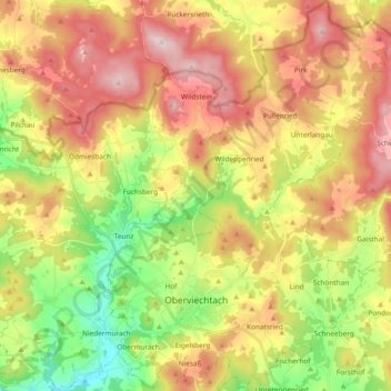
Name: Oberviechtach topographic map, elevation, terrain.
Location: Oberviechtach, Landkreis Schwandorf, Bavaria, 92526, Germany (49.43162 12.37654 49.55380 12.51418)
Average elevation: 579 m
Minimum elevation: 402 m
Maximum elevation: 766 m
Thank you for supporting this site ❤️
Make a donation
Make a donation
Gear up for your next adventure:
As an Amazon Associate, this site earns from qualifying purchases at no extra cost to you.
Other topographic maps
Click on a map to view its topography, its elevation and its terrain.
Bruck in der Oberpfalz
Germany > Bavaria > Landkreis Schwandorf > Bruck i.d.OPf.
Average elevation: 404 m