
Make a donation
Gear up for your next adventure:
As an Amazon Associate, this site earns from qualifying purchases at no extra cost to you.
Kappel-Grafenhausen topographic map
Click on the map to display elevation.
Make a donation
Gear up for your next adventure:
As an Amazon Associate, this site earns from qualifying purchases at no extra cost to you.
Kappel-Grafenhausen
Kappel-Grafenhausen (Low Alemannic: Kabbl-Groffähüüsä) is a town in the district of Ortenau in Baden-Württemberg in Germany, within the administrative region of Freiburg. Nestled between the Black Forest and the Vosges Mountains. The village spans about 2,600 hectares, which includes residential, transportation, forested areas, and water bodies. The highest elevation point reaches over 522 meters above sea level, while the lowest is around 155 meters
Make a donation
Gear up for your next adventure:
As an Amazon Associate, this site earns from qualifying purchases at no extra cost to you.
About this map
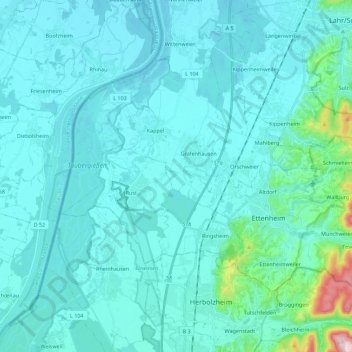
Name: Kappel-Grafenhausen topographic map, elevation, terrain.
Average elevation: 181 m
Minimum elevation: 151 m
Maximum elevation: 472 m
Make a donation
Gear up for your next adventure:
As an Amazon Associate, this site earns from qualifying purchases at no extra cost to you.
Other topographic maps
Click on a map to view its topography, its elevation and its terrain.
Obergieß
Germany > Baden-Württemberg > Ortenaukreis > Hornberg > Niederwasser
Average elevation: 717 m
Mattenhof
Germany > Baden-Württemberg > Ortenaukreis > Gutach (Schwarzwaldbahn)
Average elevation: 402 m
Make a donation
Gear up for your next adventure:
As an Amazon Associate, this site earns from qualifying purchases at no extra cost to you.
Make a donation
Gear up for your next adventure:
As an Amazon Associate, this site earns from qualifying purchases at no extra cost to you.