
Woodbridge topographic map
Interactive map
Click on the map to display elevation.
About this map
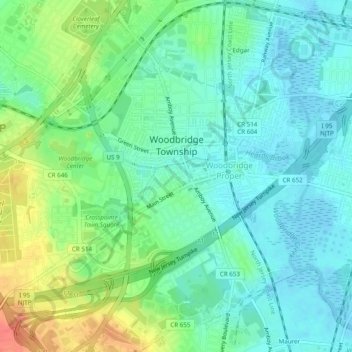
Name: Woodbridge topographic map, elevation, terrain.
Average elevation: 17 m
Minimum elevation: -3 m
Maximum elevation: 53 m
Woodbridge's geographical features make it prone to repeated flooding. It is surrounded by water on three sides: the Arthur Kill, a tidal strait to the east, and tidal rivers to the south, Raritan River, and north, Rahway River; and, much of the developed land in Woodbridge has low elevations, as little as five feet above sea level. About 19% of Woodbridge Township lies within FEMA's flood hazard areas. There is a long history of tidal flooding along the Woodbridge River in Woodbridge Proper, the Raritan in Keasbey and the Arthur Kill in Sewaren and Port Reading. In addition to tidal flooding, fluvial flooding is common. Woodbridge streams and rivers have been described as having a "high flow, flashy nature." The land is relatively impervious, and flooding is exacerbated by steep slopes and urban cover. Flooding in the South Branch Rahway River and Pumpkin Patch Brook hazard zones is predominantly fluvial. Prolonged coastal storms (nor'easters), which combine tidal and fluvial flooding, along with flow constrictions, cause an increase in the duration of flooding of the Woodbridge River and its tributaries, Heards Brook and Wedgewood Brook, which may last for days before water levels subside. Frequency of flooding has increased over time. Sea levels are rising and residential areas have moved into previous marsh land, decreasing the ability of the land to absorb excess water. A 1770 map shows that all land surrounding the Woodbridge River was salt marshes. I