
Make a donation
Gear up for your next adventure:
As an Amazon Associate, this site earns from qualifying purchases at no extra cost to you.
Wolcott topographic map
Click on the map to display elevation.
Make a donation
Gear up for your next adventure:
As an Amazon Associate, this site earns from qualifying purchases at no extra cost to you.
Wolcott
The highest point in New Haven County is found in Wolcott atop Lindsley Hill, which has an elevation of approximately 1,046 feet above sea level.
Make a donation
Gear up for your next adventure:
As an Amazon Associate, this site earns from qualifying purchases at no extra cost to you.
About this map
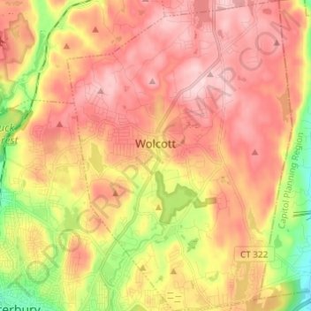
Name: Wolcott topographic map, elevation, terrain.
Average elevation: 209 m
Minimum elevation: 56 m
Maximum elevation: 320 m
Make a donation
Gear up for your next adventure:
As an Amazon Associate, this site earns from qualifying purchases at no extra cost to you.
Other topographic maps
Click on a map to view its topography, its elevation and its terrain.
Huntington
United States > Connecticut > Naugatuck Valley Planning Region > Shelton
Average elevation: 111 m
Minortown
United States > Connecticut > Naugatuck Valley Planning Region > Woodbury
Average elevation: 169 m
White Hills
United States > Connecticut > Naugatuck Valley Planning Region > Shelton
Average elevation: 124 m
Make a donation
Gear up for your next adventure:
As an Amazon Associate, this site earns from qualifying purchases at no extra cost to you.
Mad River
United States > Connecticut > Naugatuck Valley Planning Region > Waterbury > Fair Lawn
Average elevation: 134 m
Traditions
United States > Connecticut > Naugatuck Valley Planning Region > Southbury > South Britain
Average elevation: 112 m
Fox Hollow
United States > Connecticut > Naugatuck Valley Planning Region > Cheshire
Average elevation: 64 m
Westview Heights
United States > Connecticut > Naugatuck Valley Planning Region > Middlebury
Average elevation: 159 m
Make a donation
Gear up for your next adventure:
As an Amazon Associate, this site earns from qualifying purchases at no extra cost to you.
Union City
United States > Connecticut > Naugatuck Valley Planning Region > Naugatuck
Average elevation: 124 m
Warsaw Park
United States > Connecticut > Naugatuck Valley Planning Region > Ansonia
Average elevation: 107 m
Bunker Hill
United States > Connecticut > Naugatuck Valley Planning Region > Waterbury
Average elevation: 140 m
Make a donation
Gear up for your next adventure:
As an Amazon Associate, this site earns from qualifying purchases at no extra cost to you.
Cedar Land
United States > Connecticut > Naugatuck Valley Planning Region > Southbury
Average elevation: 103 m
Town Plot Hill
United States > Connecticut > Naugatuck Valley Planning Region > Waterbury
Average elevation: 127 m
Millville
United States > Connecticut > Naugatuck Valley Planning Region > Naugatuck
Average elevation: 132 m
Bunker Hill
United States > Connecticut > Naugatuck Valley Planning Region > Waterbury
Average elevation: 140 m
Make a donation
Gear up for your next adventure:
As an Amazon Associate, this site earns from qualifying purchases at no extra cost to you.
Bunker Hill
United States > Connecticut > Naugatuck Valley Planning Region > Waterbury
Average elevation: 140 m
Minortown
United States > Connecticut > Naugatuck Valley Planning Region > Woodbury
Average elevation: 169 m
Gulls Hollow
United States > Connecticut > Naugatuck Valley Planning Region > Bethlehem
Average elevation: 243 m
Allentown
United States > Connecticut > Naugatuck Valley Planning Region > Plymouth
Average elevation: 244 m
Make a donation
Gear up for your next adventure:
As an Amazon Associate, this site earns from qualifying purchases at no extra cost to you.