
Make a donation
Gear up for your next adventure:
As an Amazon Associate, this site earns from qualifying purchases at no extra cost to you.
South Lebanon topographic map
Click on the map to display elevation.
Make a donation
Gear up for your next adventure:
As an Amazon Associate, this site earns from qualifying purchases at no extra cost to you.
About this map
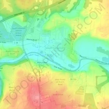
Name: South Lebanon topographic map, elevation, terrain.
Location: South Lebanon, Warren County, Ohio, 45065, United States (39.32206 -84.25437 39.38654 -84.19424)
Average elevation: 228 m
Minimum elevation: 180 m
Maximum elevation: 270 m
Make a donation
Gear up for your next adventure:
As an Amazon Associate, this site earns from qualifying purchases at no extra cost to you.
Other topographic maps
Click on a map to view its topography, its elevation and its terrain.
Make a donation
Gear up for your next adventure:
As an Amazon Associate, this site earns from qualifying purchases at no extra cost to you.
Corwin M. Nixon Pine Hill Lakes Park
United States > Ohio > Warren County > Mason
Average elevation: 250 m