
Thank you for supporting this site ❤️
Make a donation
Make a donation
Gear up for your next adventure:
As an Amazon Associate, this site earns from qualifying purchases at no extra cost to you.
Hogenakkal topographic map
Click on the map to display elevation.
Thank you for supporting this site ❤️
Make a donation
Make a donation
Gear up for your next adventure:
As an Amazon Associate, this site earns from qualifying purchases at no extra cost to you.
About this map
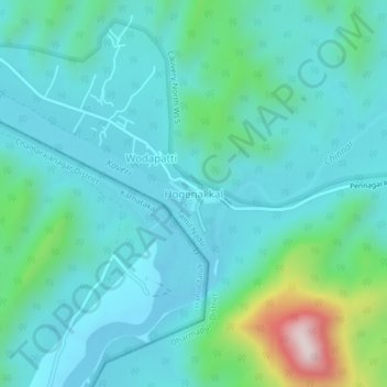
Name: Hogenakkal topographic map, elevation, terrain.
Location: Hogenakkal, Pennagaram, Dharmapuri District, Tamil Nadu, India (12.10143 77.75768 12.14143 77.79768)
Average elevation: 336 m
Minimum elevation: 233 m
Maximum elevation: 816 m
Thank you for supporting this site ❤️
Make a donation
Make a donation
Gear up for your next adventure:
As an Amazon Associate, this site earns from qualifying purchases at no extra cost to you.