
State of Mexico topographic map
Interactive map
Click on the map to display elevation.
About this map
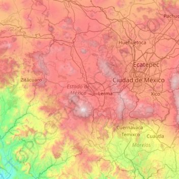
Name: State of Mexico topographic map, elevation, terrain.
Location: State of Mexico, Mexico (18.36694 -100.61309 20.28587 -98.59687)
Average elevation: 2,059 m
Minimum elevation: 233 m
Maximum elevation: 4,605 m
About seventy percent of the state has a temperate moist climate, which consists of the highlands of the Toluca Valley and the areas around Texcoco in the north, the Toluca Valley and the areas around Texcoco. Average year-round temperature varies between 12C and 18C with annual precipitation above 700 millimeters. Higher elevations, about 13% of the state, in the center and east of the state have a semicold climate with average temperatures below 16C. Hotter climes are in the relative lowlands in the south west with have an average temperature of between 18C and 22C and constitute about eight percent of the territory. The hottest regions occupy five percent of the state in the extreme southwest with temperatures averaging over 22C. The coldest areas in the highest elevations such as the Nevado de Toluca, Popocatepetl and Iztaccihuatl. Snow can be found on these elevations year round. There are some arid areas along the borders of Hidalgo and Tlaxcala with annual precipitation between 500 and 700 milliliters.
Other topographic maps
Click on a map to view its topography, its elevation and its terrain.
Querétaro
Mexico > Querétaro > Municipio de Querétaro
Querétaro, Municipio de Querétaro, Querétaro, Mexico
Average elevation: 1,921 m
Cabo San Lucas
Mexico > Baja California Sur > Los Cabos Municipality
Cabo San Lucas, Los Cabos Municipality, Baja California Sur, 23470, Mexico
Average elevation: 94 m
San Miguel de Allende
Mexico > Guanajuato > San Miguel de Allende
San Miguel de Allende, Guanajuato, Mexico
Average elevation: 1,964 m
Parque Juárez
Mexico > Puebla > Tehuacán > Tehuacán
Parque Juárez, Tehuacán, Puebla, Mexico
Average elevation: 1,628 m
Parque Juarez
Mexico > Veracruz > Santiago Tuxtla > La Cuchilla
Parque Juarez, La Cuchilla, Santiago Tuxtla, Veracruz, Mexico
Average elevation: 216 m
Cancún
Mexico > Quintana Roo > Benito Juárez
Cancún, Benito Juárez, Quintana Roo, Mexico
Average elevation: 5 m
Corales
Mexico > Guerrero > Técpan de Galeana
Corales, Técpan de Galeana, Guerrero, Mexico
Average elevation: 491 m
San Felipe Zapotitlán
Mexico > Oaxaca > Villa Sola de Vega
San Felipe Zapotitlán, Villa Sola de Vega, Oaxaca, Mexico
Average elevation: 1,763 m
Amatenango del Valle
Mexico > Chiapas > Amatenango del Valle
Amatenango del Valle, Chiapas, Mexico
Average elevation: 1,976 m
Colotitlán
Mexico > Jalisco > Tenamaxtlán
Colotitlán, Tenamaxtlán, Región Sierra de Amula, Jalisco, 48592, Mexico
Average elevation: 1,412 m
Bosques de las Lomas
Mexico > State of Mexico > Ciudad Satélite
Bosques de las Lomas, Miguel Hidalgo, Ciudad Satélite, Mexico City, State of Mexico, 11910, Mexico
Average elevation: 2,414 m
Lázaro Cárdenas
Mexico > State of Mexico > Naucalpan de Juárez
Lázaro Cárdenas, Naucalpan de Juárez, State of Mexico, 53569, Mexico
Average elevation: 2,282 m
Tlajomulco de Zúñiga
Tlajomulco de Zúñiga, Región Centro, Jalisco, Mexico
Average elevation: 1,670 m
San Antonio la Isla
San Antonio la Isla, State of Mexico, Mexico
Average elevation: 2,585 m
San Cristóbal
Mexico > Chiapas > San Cristóbal de las Casas
San Cristóbal, San Cristóbal de las Casas, Chiapas, 29200, Mexico
Average elevation: 2,038 m
Cedros Island
Mexico > Baja California > Municipio de Ensenada
Cedros Island, Municipio de Ensenada, Baja California, 22990, Mexico
Average elevation: 67 m
Yucatán Peninsula
Mexico > Quintana Roo > Othón P. Blanco
Yucatán Peninsula, Othón P. Blanco, Quintana Roo, Mexico
Average elevation: 100 m
Guadalajara
Mexico > Jalisco > Guadalajara
Guadalajara, Jalisco, 44360, Mexico
Average elevation: 1,572 m
Malinche
Mexico > Tlaxcala > Teolocholco
Malinche, Teolocholco, Tlaxcala, Mexico
Average elevation: 3,911 m
Tepeji del Río de Ocampo
Tepeji del Río de Ocampo, Hidalgo, Mexico
Average elevation: 2,296 m
San Juan Colorado
Mexico > Oaxaca > San Juan Colorado
San Juan Colorado, Oaxaca, 71750, Mexico
Average elevation: 412 m
San Miguel
Mexico > Nuevo León > García
San Miguel, García, Nuevo León, Mexico
Average elevation: 1,431 m