Geolocate

Rain topographic map

Click on the map to display elevation.

About this map
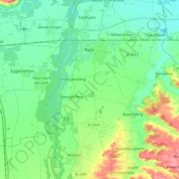
Name: Rain topographic map, elevation, terrain.

Location: Rain, Rain (Schwaben), Landkreis Donau-Ries, Bavaria, 86641, Germany (48.60915 10.87135 48.72124 11.03955)

Average elevation: 414 m

Minimum elevation: 386 m

Maximum elevation: 486 m

Other topographic maps

Click on a map to view its topography, its elevation and its terrain.

Gunzenheim

Germany > Bavaria > Landkreis Donau-Ries

Average elevation: 496 m

Baldingen

Germany > Bavaria > Landkreis Donau-Ries > Nördlingen

Average elevation: 434 m

Holheim

Germany > Bavaria > Landkreis Donau-Ries > Nördlingen

Average elevation: 473 m

Baldingen

Germany > Bavaria > Landkreis Donau-Ries > Nördlingen

Average elevation: 434 m

Holheim

Germany > Bavaria > Landkreis Donau-Ries > Nördlingen

Average elevation: 473 m

Gear up for your next adventure:

🧤Hiking Gloves - Warm and durable gloves for cold-weather walks
🧦Merino Wool Hiking Socks - Moisture-wicking socks to prevent blisters during long mountain walks
🔪Outdoor Multi-Tools - Versatile tools for gear repairs and food prep in the wild
⌚GPS Outdoor Watches - Watches with GPS tracking for hiking and exploration
🪢Paracord - Multi-purpose cord for camping and survival

As an Amazon Associate, this site earns from qualifying purchases at no extra cost to you.