
Eastsound topographic map
Interactive map
Click on the map to display elevation.
About this map
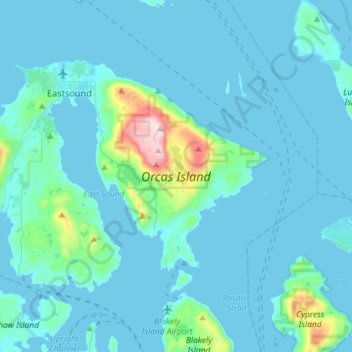
Name: Eastsound topographic map, elevation, terrain.
Average elevation: 59 m
Minimum elevation: -1 m
Maximum elevation: 723 m
Mount Constitution (elevation 2,409 feet (734 meters) is the highest point in the San Juan islands. The mountain is part of Moran State Park, the largest public recreation area in the San Juan Islands, and the largest State Park in Washington. Moran State Park encompasses over 5,000 acres (2,000 hectares) of woodland and has several lakes, including Cascade Lake, Mountain Lake, Summit Lake, and Twin Lakes, and numerous waterfalls.
Other topographic maps
Click on a map to view its topography, its elevation and its terrain.
San Juan Islands National Wildlife Refuge
United States > Washington > San Juan County
San Juan Islands National Wildlife Refuge, San Juan County, Washington, United States
Average elevation: 24 m
O'Neal Island
United States > Washington > San Juan County
O'Neal Island, San Juan County, Washington, United States
Average elevation: 18 m
Friday Harbor
United States > Washington > San Juan County
Friday Harbor, San Juan County, Washington, 98250, United States
Average elevation: 28 m
Ben Nevis
United States > Washington > San Juan County
Ben Nevis, San Juan County, Washington, 98286, United States
Average elevation: 49 m
Spencer Lake
United States > Washington > San Juan County > Thatcher
Spencer Lake, Thatcher, San Juan County, Washington, United States
Average elevation: 150 m
Eastsound
United States > Washington > San Juan County
Eastsound, San Juan County, Washington, 98245, United States
Average elevation: 74 m