
Belaya Kalitva topographic map
Interactive map
Click on the map to display elevation.
About this map
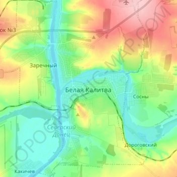
Name: Belaya Kalitva topographic map, elevation, terrain.
Average elevation: 65 m
Minimum elevation: 15 m
Maximum elevation: 157 m
Other topographic maps
Click on a map to view its topography, its elevation and its terrain.
Богураевское сельское поселение
Russia > Rostov Oblast > Belokalitvinsky District
Богураевское сельское поселение, Belokalitvinsky District, Rostov Oblast, Southern Federal District, Russia
Average elevation: 117 m
Калитва
Russia > Rostov Oblast > Belokalitvinsky District > Дороговский
Калитва, Дороговский, Нижнепоповское сельское поселение, Belokalitvinsky District, Rostov Oblast, Southern Federal District, 347001, Russia
Average elevation: 47 m