
Monticello topographic map
Interactive map
Click on the map to display elevation.
About this map
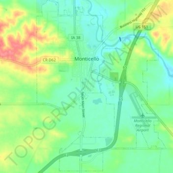
Name: Monticello topographic map, elevation, terrain.
Location: Monticello, Jones County, Iowa, 52310, United States (42.20134 -91.20931 42.25778 -91.15166)
Average elevation: 262 m
Minimum elevation: 239 m
Maximum elevation: 306 m
Other topographic maps
Click on a map to view its topography, its elevation and its terrain.
Onslow
United States > Iowa > Jones County > Onslow
Onslow, Jones County, Iowa, United States
Average elevation: 277 m