Geolocate

Woolwine topographic map

Click on the map to display elevation.

About this map

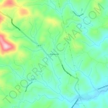
Name: Woolwine topographic map, elevation, terrain.

Location: Woolwine, Patrick County, Virginia, 24185, United States (36.76986 -80.29728 36.80986 -80.25728)

Average elevation: 454 m

Minimum elevation: 376 m

Maximum elevation: 647 m

Other topographic maps

Click on a map to view its topography, its elevation and its terrain.

Stuart

United States > Virginia > Patrick County

Average elevation: 411 m

Stuart

United States > Virginia > Patrick County

Average elevation: 416 m

Stuart

United States > Virginia > Patrick County

Average elevation: 411 m

Gear up for your next adventure:

🧼Biodegradable Soap - Leave-no-trace hygiene for multi-day mountain treks
🔋Solar Chargers - Eco-friendly charging solutions for outdoor use
🛌Sleeping Mats - Insulated mats for comfortable outdoor sleeping
🧘Folding Sit Mats - Dry and warm seat for map-reading breaks on damp ground
🥾Trekking Poles - Poles to improve stability on uneven terrain

As an Amazon Associate, this site earns from qualifying purchases at no extra cost to you.