
Fort St. James topographic map
Interactive map
Click on the map to display elevation.
About this map
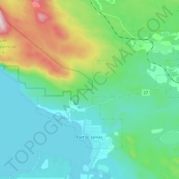
Name: Fort St. James topographic map, elevation, terrain.
Average elevation: 831 m
Minimum elevation: 671 m
Maximum elevation: 1,372 m
Other topographic maps
Click on a map to view its topography, its elevation and its terrain.
Fraser Lake
Canada > British Columbia > Regional District of Bulkley-Nechako
Fraser Lake, Regional District of Bulkley-Nechako, British Columbia, Canada
Average elevation: 824 m