
Make a donation
Gear up for your next adventure:
As an Amazon Associate, this site earns from qualifying purchases at no extra cost to you.
Woodruff topographic map
Click on the map to display elevation.
Make a donation
Gear up for your next adventure:
As an Amazon Associate, this site earns from qualifying purchases at no extra cost to you.
About this map
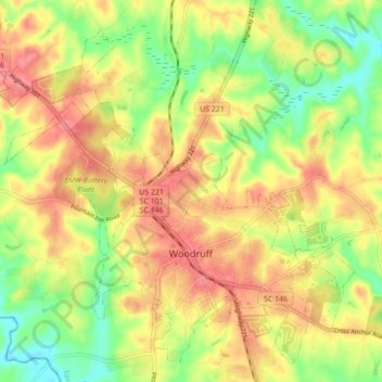
Name: Woodruff topographic map, elevation, terrain.
Location: Woodruff, Spartanburg County, South Carolina, United States (34.71896 -82.08646 34.78352 -81.99977)
Average elevation: 212 m
Minimum elevation: 171 m
Maximum elevation: 246 m
Make a donation
Gear up for your next adventure:
As an Amazon Associate, this site earns from qualifying purchases at no extra cost to you.
Other topographic maps
Click on a map to view its topography, its elevation and its terrain.
Make a donation
Gear up for your next adventure:
As an Amazon Associate, this site earns from qualifying purchases at no extra cost to you.
Make a donation
Gear up for your next adventure:
As an Amazon Associate, this site earns from qualifying purchases at no extra cost to you.
Make a donation
Gear up for your next adventure:
As an Amazon Associate, this site earns from qualifying purchases at no extra cost to you.
East Spartanburg
United States > South Carolina > Spartanburg County > Spartanburg
Average elevation: 227 m
Northbrook Park
United States > South Carolina > Spartanburg County > Northbrook Park
Average elevation: 253 m
Waldrop Crossroads
United States > South Carolina > Spartanburg County > Waldrop Crossroads
Average elevation: 194 m
Make a donation
Gear up for your next adventure:
As an Amazon Associate, this site earns from qualifying purchases at no extra cost to you.
Spartanburg
United States > South Carolina > Spartanburg County > Spartanburg
Average elevation: 234 m