Geolocate

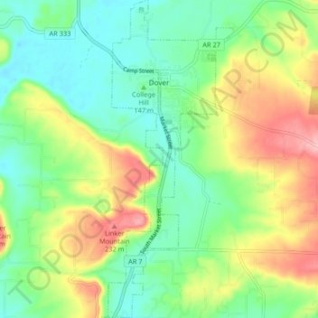
Dover topographic map

Click on the map to display elevation.

Dover

The mild hills historically supported oak-hickory forest or oak-hickory-pine forest. Elevation changes and soil types make the Arkansas Valley Hills largely unsuitable for row agriculture. Instead, forest has been cleared for pastureland, poultry farming or ranching. Logging remains an important land use where elevation or soil makes livestock farming unsuitable. Many of the smaller streams and watercourses are completely dry in summer.

Wikipedia (CC-BY-SA 3.0)

About this map

Name: Dover topographic map, elevation, terrain.

Location: Dover, Pope County, Arkansas, 72837, United States (35.35115 -93.12742 35.41773 -93.09518)

Average elevation: 164 m

Minimum elevation: 113 m

Maximum elevation: 252 m

Other topographic maps

Click on a map to view its topography, its elevation and its terrain.
Moreland

United States > Arkansas > Pope County

Average elevation: 236 m

Rock Springs

United States > Arkansas > Pope County

Average elevation: 218 m

Sand Gap

United States > Arkansas > Pope County

Average elevation: 561 m

Holla Bend

United States > Arkansas > Pope County > Pottsville

Average elevation: 98 m

Mulberry Mountain

United States > Arkansas > Pope County

Average elevation: 516 m

Smyrna

United States > Arkansas > Pope County

Average elevation: 402 m

Gear up for your next adventure:

⌚Altimeter Watches - Watches measuring altitude for mountain activities
🌦️Portable Weather Meters - Handheld tools for monitoring weather conditions
❄️Walking Crampons - Added traction for icy slopes and winter peak bagging
🕶️Glacier Goggles - Maximum protection for high-altitude snow topography
🦯Walking Poles - Supportive poles for long-distance walking

As an Amazon Associate, this site earns from qualifying purchases at no extra cost to you.