Geolocate

Hampton topographic map

Click on the map to display elevation.

About this map

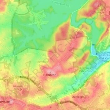
Name: Hampton topographic map, elevation, terrain.

Location: Hampton, Baltimore County, Maryland, United States (39.40195 -76.60851 39.44875 -76.53669)

Average elevation: 108 m

Minimum elevation: 47 m

Maximum elevation: 166 m

Gear up for your next adventure:

🧭Emergency Beacons - Safety beacons for remote outdoor locations
🥾Men's Waterproof Hiking Boots - Durable footwear with deep lugs for muddy and rocky UK terrains
🚲Bikepacking Frame Bags - Storage for tools and navigation gear on long off-road rides
🍲Portable Camping Stoves - Fast-boiling stoves for hot meals on remote topographic survey trips
🥾Hiking Boot Waterproofing Wax - Maintain the lifespan of your leather trekking boots

As an Amazon Associate, this site earns from qualifying purchases at no extra cost to you.