
Lattakia District topographic map
Interactive map
Click on the map to display elevation.
About this map
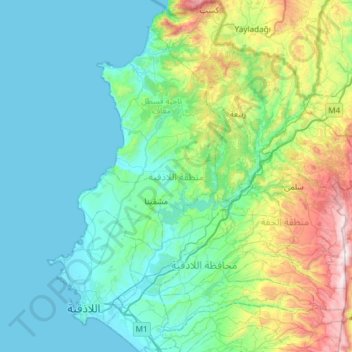
Name: Lattakia District topographic map, elevation, terrain.
Location: Lattakia District, Lattakia Governorate, Syria (35.45921 35.71657 35.94052 36.15335)
Average elevation: 284 m
Minimum elevation: 0 m
Maximum elevation: 1,537 m
Other topographic maps
Click on a map to view its topography, its elevation and its terrain.
Al-Qardaha
Qardaha has a hot-summer Mediterranean climate (Köppen climate classification: Csa). Qardaha is in a mountainous area, but its altitude is only between 350 and 500 meters. It is in a beautiful forested area. Qardaha has much rainfall. The average high temperature in July is 29 °C, and in January is 7 °C.…
Average elevation: 335 m