
Abadía topographic map
Interactive map
Click on the map to display elevation.
Abadía
Abadía (Spanish pronunciation: [a.βaˈði.a]) is a Spanish municipality located at an altitude of 442 metres above sea-level in the Autonomous Community of Estremadura, province of Cáceres. In 2001 its population was 272 – c. 6 people per square kilometre within an area of 45 km².
About this map
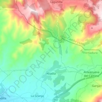
Name: Abadía topographic map, elevation, terrain.
Location: Abadía, Cáceres, Extremadura, 10748, Spain (40.24149 -6.06238 40.31839 -5.94067)
Average elevation: 610 m
Minimum elevation: 388 m
Maximum elevation: 1,084 m
Other topographic maps
Click on a map to view its topography, its elevation and its terrain.
Castillo de Piedrabuena
Spain > Extremadura > Tierra de Badajoz > San Vicente de Alcántara > Dehesa Piedrabuena
Average elevation: 364 m