
Make a donation
Gear up for your next adventure:
As an Amazon Associate, this site earns from qualifying purchases at no extra cost to you.
Rumuruti topographic map
Click on the map to display elevation.
Make a donation
Gear up for your next adventure:
As an Amazon Associate, this site earns from qualifying purchases at no extra cost to you.
About this map
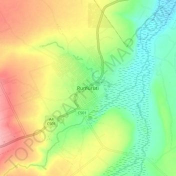
Name: Rumuruti topographic map, elevation, terrain.
Location: Rumuruti, Laikipia West, Laikipia County, Rift Valley, Kenya (0.22903 36.50037 0.30903 36.58037)
Average elevation: 1,853 m
Minimum elevation: 1,802 m
Maximum elevation: 1,918 m
Make a donation
Gear up for your next adventure:
As an Amazon Associate, this site earns from qualifying purchases at no extra cost to you.
Other topographic maps
Click on a map to view its topography, its elevation and its terrain.
Nyahururu
Kenya > Laikipia County > Laikipia West
Nyahururu is also frequented by marathon and cross-country runners for practicing before major events due to its high altitude.
Average elevation: 2,348 m
Nyahururu
Kenya > Laikipia County > Laikipia West
Nyahururu is also frequented by marathon and cross-country runners for practicing before major events due to its high altitude.
Average elevation: 2,348 m