
Chihuahua topographic map
Interactive map
Click on the map to display elevation.
About this map
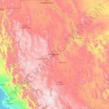
Name: Chihuahua topographic map, elevation, terrain.
Location: Chihuahua, Mexico (25.55866 -109.07498 31.78390 -103.30669)
Average elevation: 1,397 m
Minimum elevation: -1 m
Maximum elevation: 3,119 m
The main mountain range in the state is the Sierra Madre Occidental reaching a maximum altitude of 10,826 ft (3,300 m) known as Cerro Mohinora. Mountains account for one third of the state's surface area which include large coniferous forests. The climate in the mountainous regions varies. Chihuahua has more forests than any other state in Mexico making the area a bountiful source of wood; the mountainous areas are rich in minerals important to Mexico's mining industry. Precipitation and temperature in the mountainous areas depends on the elevation. Between the months of November and March snow storms are possible in the lower elevations and are frequent in the higher elevations. There are several watersheds located in the Sierra Madre Occidental all of the water that flows through the state; most of the rivers finally empty into the Río Grande. Temperatures in some canyons in the state reach over 100 °F (38 °C) in the summer while the same areas rarely drop below 32 °F (0 °C) in the winter. Microclimates found in the heart of the Sierra Madre Occidental in the state could be considered tropical, and wild tropical plants have been found in some canyons. La Barranca del Cobre, or Copper Canyon, a spectacular canyon system larger and deeper than the Grand Canyon; the canyon also contains Mexico's two tallest waterfalls: Basaseachic Falls and Piedra Volada. There are two national parks found in the mountainous area of the state: Cumbres de Majalca National Park and Basaseachic Falls National Park.
Other topographic maps
Click on a map to view its topography, its elevation and its terrain.
Rancho Nuevo
Rancho Nuevo, Terrenos del Lote "San Miguel Mecatepec", Tihuatlán, Veracruz, 92933, Mexico
Average elevation: 82 m
Querétaro
Mexico > Querétaro > Municipio de Querétaro
Querétaro, Municipio de Querétaro, Querétaro, Mexico
Average elevation: 1,921 m
Cancún
Mexico > Quintana Roo > Benito Juárez
Cancún, Benito Juárez, Quintana Roo, Mexico
Average elevation: 5 m
San Miguel de Allende
Mexico > Guanajuato > San Miguel de Allende
San Miguel de Allende, Guanajuato, Mexico
Average elevation: 1,964 m
Cabo San Lucas
Mexico > Baja California Sur > Los Cabos Municipality
Cabo San Lucas, Los Cabos Municipality, Baja California Sur, 23470, Mexico
Average elevation: 94 m
Parque Juárez
Mexico > Puebla > Tehuacán > Tehuacán
Parque Juárez, Tehuacán, Puebla, Mexico
Average elevation: 1,628 m
Parque Juarez
Mexico > Veracruz > Santiago Tuxtla > La Cuchilla
Parque Juarez, La Cuchilla, Santiago Tuxtla, Veracruz, Mexico
Average elevation: 216 m
Corales
Mexico > Guerrero > Técpan de Galeana
Corales, Técpan de Galeana, Guerrero, Mexico
Average elevation: 491 m
San Felipe Zapotitlán
Mexico > Oaxaca > Villa Sola de Vega
San Felipe Zapotitlán, Villa Sola de Vega, Oaxaca, Mexico
Average elevation: 1,763 m
Amatenango del Valle
Mexico > Chiapas > Amatenango del Valle
Amatenango del Valle, Chiapas, Mexico
Average elevation: 1,976 m
Colotitlán
Mexico > Jalisco > Tenamaxtlán
Colotitlán, Tenamaxtlán, Región Sierra de Amula, Jalisco, 48592, Mexico
Average elevation: 1,412 m
Bosques de las Lomas
Mexico > State of Mexico > Ciudad Satélite
Bosques de las Lomas, Miguel Hidalgo, Ciudad Satélite, Mexico City, State of Mexico, 11910, Mexico
Average elevation: 2,414 m
Lázaro Cárdenas
Mexico > State of Mexico > Naucalpan de Juárez
Lázaro Cárdenas, Naucalpan de Juárez, State of Mexico, 53569, Mexico
Average elevation: 2,282 m
Tlajomulco de Zúñiga
Tlajomulco de Zúñiga, Región Centro, Jalisco, Mexico
Average elevation: 1,670 m
San Antonio la Isla
San Antonio la Isla, State of Mexico, Mexico
Average elevation: 2,585 m
San Cristóbal
Mexico > Chiapas > San Cristóbal de las Casas
San Cristóbal, San Cristóbal de las Casas, Chiapas, 29200, Mexico
Average elevation: 2,038 m
Cedros Island
Mexico > Baja California > Municipio de Ensenada
Cedros Island, Municipio de Ensenada, Baja California, 22990, Mexico
Average elevation: 67 m
Yucatán Peninsula
Mexico > Quintana Roo > Othón P. Blanco
Yucatán Peninsula, Othón P. Blanco, Quintana Roo, Mexico
Average elevation: 100 m
Guadalajara
Mexico > Jalisco > Guadalajara
Guadalajara, Jalisco, 44360, Mexico
Average elevation: 1,572 m
Malinche
Mexico > Tlaxcala > Teolocholco
Malinche, Teolocholco, Tlaxcala, Mexico
Average elevation: 3,911 m
Tepeji del Río de Ocampo
Tepeji del Río de Ocampo, Hidalgo, Mexico
Average elevation: 2,296 m