
Lisle topographic map
Interactive map
Click on the map to display elevation.
About this map
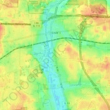
Name: Lisle topographic map, elevation, terrain.
Location: Lisle, DuPage County, Illinois, 60532, United States (41.75981 -88.11874 41.81862 -88.04918)
Average elevation: 221 m
Minimum elevation: 198 m
Maximum elevation: 242 m
Other topographic maps
Click on a map to view its topography, its elevation and its terrain.
Elmhurst
United States > Illinois > DuPage County
Due to local topography, the town has had a tendency to flood in the past after large rainfalls; the city is currently undertaking a large effort to mitigate future flooding.
Average elevation: 207 m
Elmhurst
United States > Illinois > DuPage County
Due to local topography, the town has had a tendency to flood in the past after large rainfalls; the city is currently undertaking a large effort to mitigate future flooding.
Average elevation: 207 m