
Make a donation
Gear up for your next adventure:
As an Amazon Associate, this site earns from qualifying purchases at no extra cost to you.
Orcival topographic map
Click on the map to display elevation.
Make a donation
Gear up for your next adventure:
As an Amazon Associate, this site earns from qualifying purchases at no extra cost to you.
About this map
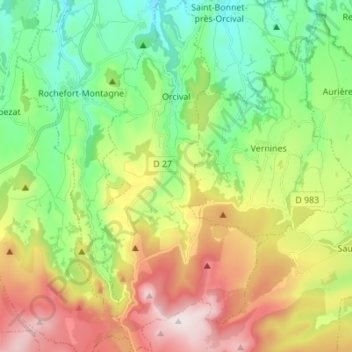
Name: Orcival topographic map, elevation, terrain.
Average elevation: 1,062 m
Minimum elevation: 777 m
Maximum elevation: 1,525 m
Make a donation
Gear up for your next adventure:
As an Amazon Associate, this site earns from qualifying purchases at no extra cost to you.
Other topographic maps
Click on a map to view its topography, its elevation and its terrain.
Make a donation
Gear up for your next adventure:
As an Amazon Associate, this site earns from qualifying purchases at no extra cost to you.
La Ville-Tour
France > Auvergne-Rhône-Alpes > Puy-de-Dôme > Besse-et-Saint-Anastaise
Average elevation: 1,108 m
Make a donation
Gear up for your next adventure:
As an Amazon Associate, this site earns from qualifying purchases at no extra cost to you.
Pôle Aqualudique
France > Auvergne-Rhône-Alpes > Puy-de-Dôme > La Bourboule > Les Vernières
Average elevation: 996 m
Nadaillat
France > Auvergne-Rhône-Alpes > Puy-de-Dôme > Saint-Genès-Champanelle
Average elevation: 822 m
Make a donation
Gear up for your next adventure:
As an Amazon Associate, this site earns from qualifying purchases at no extra cost to you.