
Cantón Liberia topographic map
Interactive map
Click on the map to display elevation.
About this map
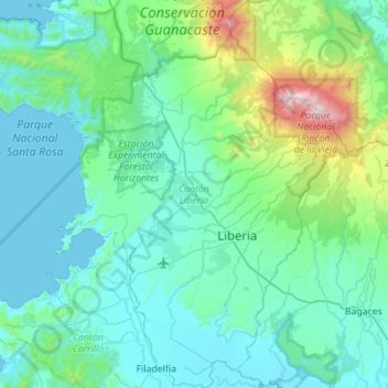
Name: Cantón Liberia topographic map, elevation, terrain.
Location: Cantón Liberia, Provincia Guanacaste, Costa Rica (10.41830 -85.69929 10.96515 -85.29202)
Average elevation: 237 m
Minimum elevation: 0 m
Maximum elevation: 1,878 m
Liberia has an area of 1,436.47 km2 and a mean elevation of 193 metres. Prominent geologic features of Liberia include Cerro Cacao (Cacao Mountain) and Rincón de la Vieja. The latter is the center of the Rincón de la Vieja Volcano National Park. The canton also includes the most visited portion of Santa Rosa National Park on its northwest border. The Río Salto delineates the southwestern border as far as the Tempisque River, and the Tempisque forms the border on the southeast as far as the Bahía Naranjo (Orange Bay).
Other topographic maps
Click on a map to view its topography, its elevation and its terrain.
Rincón de la Vieja Volcano National Park
Rincón de la Vieja Volcano National Park, Cantón Liberia, Provincia Guanacaste, 50105, Costa Rica
Average elevation: 759 m
Liberia
Liberia, Cantón Liberia, Provincia Guanacaste, 50101, Costa Rica
Average elevation: 203 m