Geolocate

Portlaoise topographic map

Click on the map to display elevation.

About this map
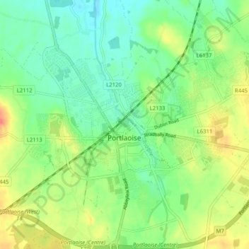
Name: Portlaoise topographic map, elevation, terrain.

Location: Portlaoise, The Municipal District of Portlaoise, County Laois, Leinster, Ireland (53.01759 -7.33080 53.05539 -7.25319)

Average elevation: 101 m

Minimum elevation: 81 m

Maximum elevation: 131 m

Other topographic maps

Click on a map to view its topography, its elevation and its terrain.
Timahoe

Ireland > County Laois

Average elevation: 146 m

Newtown

Ireland > County Laois

Average elevation: 187 m

Timahoe Round Tower

Ireland > County Laois

Average elevation: 137 m

Cullenagh Mountain

Ireland > County Laois

Average elevation: 226 m

Glasha

Ireland > County Laois

Average elevation: 58 m

Sheffield Cross

Ireland > County Laois

Average elevation: 119 m

Rosenallis

Ireland > County Laois

Average elevation: 114 m

Knockardagur

Ireland > County Laois

Average elevation: 248 m

Gear up for your next adventure:

🥤Collapsible Water Bottles - Save space in your rucksack as you consume your water
🎒Replacement Sternum Straps - Repair parts for hiking rucksacks
🧴Tick Removal Tools - Small, essential health tool for UK woodland and moorland
🦯Walking Poles - Supportive poles for long-distance walking
🔋Rechargeable Batteries - Eco-friendly power for headlamps and older GPS units

As an Amazon Associate, this site earns from qualifying purchases at no extra cost to you.