Saspul topographic map
Interactive map
Click on the map to display elevation.
About this map
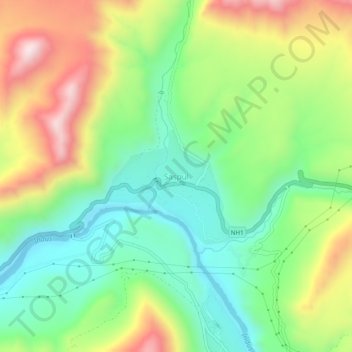
Name: Saspul topographic map, elevation, terrain.
Location: Saspul, Khalsi tehsil, Distrikt Leh, Ladakh, Indien (34.22661 77.14397 34.26661 77.18397)
Average elevation: 3,278 m
Minimum elevation: 3,036 m
Maximum elevation: 3,662 m
Other topographic maps
Click on a map to view its topography, its elevation and its terrain.
Debring
Indien > Ladakh > Khalsi tehsil
Debring, Khalsi tehsil, Distrikt Leh, Ladakh, Indien
Average elevation: 4,380 m
Lingshed
Indien > Ladakh > Khalsi tehsil
Lingshed, Khalsi tehsil, Distrikt Leh, Ladakh, Indien
Average elevation: 4,209 m
Lamayuru
Indien > Ladakh > Khalsi tehsil
Lamayuru, Khalsi tehsil, Distrikt Leh, Ladakh, Indien
Average elevation: 3,691 m
Chulichan
Indien > Ladakh > Khalsi tehsil
Chulichan, Khalsi tehsil, Distrikt Leh, Ladakh, Indien
Average elevation: 3,549 m