
Make a donation
Gear up for your next adventure:
As an Amazon Associate, this site earns from qualifying purchases at no extra cost to you.
Palanpur topographic map
Click on the map to display elevation.
Make a donation
Gear up for your next adventure:
As an Amazon Associate, this site earns from qualifying purchases at no extra cost to you.
Palanpur
Palanpur is located at 24°06′N 72°15′E / 24.10°N 72.25°E / 24.10; 72.25. It has an average elevation of 209 metres (685 ft).
Make a donation
Gear up for your next adventure:
As an Amazon Associate, this site earns from qualifying purchases at no extra cost to you.
About this map
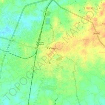
Name: Palanpur topographic map, elevation, terrain.
Location: Palanpur, Palanpur Taluka, Banaskantha, Gujarat, 385001, India (24.15056 72.40797 24.18765 72.45691)
Average elevation: 218 m
Minimum elevation: 201 m
Maximum elevation: 236 m
Make a donation
Gear up for your next adventure:
As an Amazon Associate, this site earns from qualifying purchases at no extra cost to you.
Other topographic maps
Click on a map to view its topography, its elevation and its terrain.
Jagana
India > Gujarat > Palanpur Taluka
Jagana is located at an altitude of 252m (830 feet) at 24°7'30 N, 72°25'15 E. It is believed to be founded by Jagdev whose brother Pal Parmar founded Palanpur.
Average elevation: 200 m
Palanpur
India > Gujarat > Palanpur Taluka > Palanpur
Palanpur is located at 24°06′N 72°15′E / 24.10°N 72.25°E / 24.10; 72.25. It has an average elevation of 209 metres (685 ft).
Average elevation: 204 m