Geolocate

Taybeh topographic map

Click on the map to display elevation.

About this map

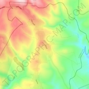
Name: Taybeh topographic map, elevation, terrain.

Location: Taybeh, Area B, West Bank, Palestinian Territory (31.93352 35.28044 31.97352 35.32044)

Average elevation: 774 m

Minimum elevation: 584 m

Maximum elevation: 976 m

Other topographic maps

Click on a map to view its topography, its elevation and its terrain.

Abu Dis

Palestinian Territory > Area B

Average elevation: 619 m

Abu Dis

Palestinian Territory > Area B

Average elevation: 619 m

Gear up for your next adventure:

🛌Sleeping Mats - Insulated mats for comfortable outdoor sleeping
🧤Thermal Touchscreen Gloves - Stay warm while operating your GPS or smartphone camera
🥾Hiking Boot Waterproofing Wax - Maintain the lifespan of your leather trekking boots
📱Rugged Phone Cases - Heavy-duty protection for smartphones used as secondary GPS tools
📷Camera Straps - Secure straps for carrying cameras while walking

As an Amazon Associate, this site earns from qualifying purchases at no extra cost to you.