
Make a donation
Gear up for your next adventure:
As an Amazon Associate, this site earns from qualifying purchases at no extra cost to you.
Lauenen topographic map
Click on the map to display elevation.
Make a donation
Gear up for your next adventure:
As an Amazon Associate, this site earns from qualifying purchases at no extra cost to you.
About this map
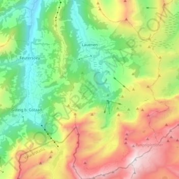
Name: Lauenen topographic map, elevation, terrain.
Average elevation: 1,882 m
Minimum elevation: 1,063 m
Maximum elevation: 3,221 m
Make a donation
Gear up for your next adventure:
As an Amazon Associate, this site earns from qualifying purchases at no extra cost to you.
Other topographic maps
Click on a map to view its topography, its elevation and its terrain.
Sankt Stephan
Switzerland > Bern > Obersimmental-Saanen administrative district > St. Stephan
Average elevation: 1,310 m
Gstaad
Switzerland > Bern > Obersimmental-Saanen administrative district
Long known for its walking and hiking trails of varying degrees of difficulty, the mountain air and ambiance attract guests year-round from around the world. Gstaad is also known for its ski and cross-country slopes and winter hiking trails. Glacier 3000 is a major attraction, offering guaranteed snow from…
Average elevation: 1,245 m
Make a donation
Gear up for your next adventure:
As an Amazon Associate, this site earns from qualifying purchases at no extra cost to you.
Leiterli
Switzerland > Bern > Obersimmental-Saanen administrative district > Lenk
Average elevation: 1,791 m
Jaunpass
Switzerland > Bern > Obersimmental-Saanen administrative district > Boltigen
Average elevation: 1,444 m
Sankt Stephan
Switzerland > Bern > Obersimmental-Saanen administrative district > St. Stephan > Sankt Stephan
Average elevation: 1,310 m
Make a donation
Gear up for your next adventure:
As an Amazon Associate, this site earns from qualifying purchases at no extra cost to you.
Saanen
Switzerland > Bern > Obersimmental-Saanen administrative district > Saanen > Saanen
Average elevation: 1,222 m
Stand
Switzerland > Bern > Obersimmental-Saanen administrative district > Saanen
Average elevation: 1,746 m