
Make a donation
Gear up for your next adventure:
As an Amazon Associate, this site earns from qualifying purchases at no extra cost to you.
San Fernando topographic map
Click on the map to display elevation.
Make a donation
Gear up for your next adventure:
As an Amazon Associate, this site earns from qualifying purchases at no extra cost to you.
About this map
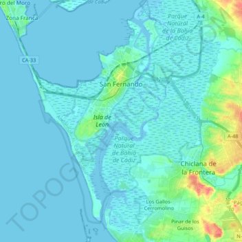
Name: San Fernando topographic map, elevation, terrain.
Location: San Fernando, Bay of Cádiz, Cádiz, Andalusia, 11100, Spain (36.37861 -6.24179 36.50996 -6.16823)
Average elevation: 6 m
Minimum elevation: -2 m
Maximum elevation: 53 m
Make a donation
Gear up for your next adventure:
As an Amazon Associate, this site earns from qualifying purchases at no extra cost to you.
Other topographic maps
Click on a map to view its topography, its elevation and its terrain.
Poblado de Doña Blanca
Spain > Andalusia > Bay of Cádiz > El Puerto de Santa María
Average elevation: 13 m
Pinar de los Guisos
Spain > Andalusia > Bay of Cádiz > Chiclana de la Frontera
Average elevation: 18 m