
Port Dover topographic map
Interactive map
Click on the map to display elevation.
About this map
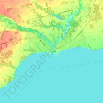
Name: Port Dover topographic map, elevation, terrain.
Location: Port Dover, Norfolk County, Ontario, N0A 1N0, Canada (42.74457 -80.24052 42.82457 -80.16052)
Average elevation: 187 m
Minimum elevation: 169 m
Maximum elevation: 222 m
Other topographic maps
Click on a map to view its topography, its elevation and its terrain.
Simcoe
Canada > Ontario > Norfolk County
Simcoe, Norfolk County, Ontario, N3Y 2E5, Canada
Average elevation: 227 m